Daily, Weekly and Loop views are available by clicking on the tabs within the page. (See the description of each below.) A complete list of images, Page Help, and a page key are also available by clicking clicking on the text links. Clicking on "Go to Region" allows you to quickly navigate between areas, sectors and states.
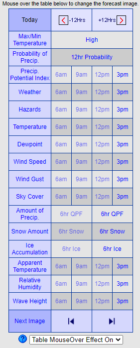
- Click on the day text ("Today" in the example graphic) to skip to the desired day.
- Click on "-12 Hrs." or "+12 Hrs." to move the time back or ahead 12 hours, then roll over the chart to change forecast graphic.
- Step Image allows the user to step the image displayed back/forward one time period by clicking the back and forward buttons.
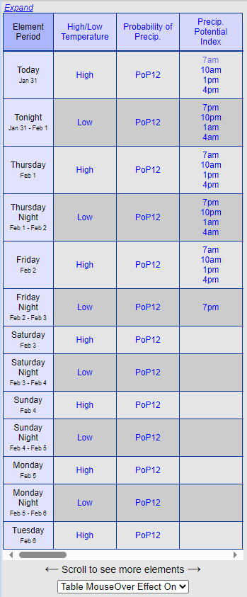
- Table MouseOver: By default the table above changes the time of the displayed weather graphic when the user moves the mouse over the time periods. However, by selecting "Table MouseOver Effect Off", clicking is required to change the time of the displayed weather graphic.
- Click on the Weather Element name for a description and element units of measure.
- Times that display dimmed are no longer available.
- Roll over the chart to change the forecast graphic valid times.
- Times that display dimmed are no longer available.
- Scroll to the right to see different forecast weather elements.
- Table MouseOver: By default the table above changes the time of the displayed weather graphic when the user moves the mouse over the time periods. However, by selecting "Table MouseOver Effect Off", clicking is required to change the time of the displayed weather graphic.
- Click on the Weather Element name for a description and element units of measure.
- Click on expand to show more forecast elements at a time.
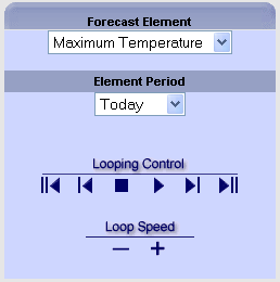
The Loops Page View provides a way to loop through a weather element quickly. Some features include:
- Select a Forecast Element by using the pull-down menu (the default in Maximum Temperature)
- Next, you can select the Valid Time that you wish to see.
- Or, you can utilize the Looping Controls to play, step back, step forward, or quickly go to the first or last time period for the selected element.
- The rate of the looping can be controled by pressing the "-" or "+" button several times.
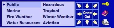
The Navigation section is located in the upper right of the page. Some features include:
- Navigation arrows to move to adjacent locations, plus a zoom out button to see a larger area in less detail.
- A Key button which provides information about how to interpret the graphics.
- The print button allows the user to print the forecast image currently displayed on the page.
- Click on "City Forecasts" for a list of cities and a brief sample of the forecast data.
- Click on the Question Mark for this help page.
- Click an element category to view forecast elements that apply to each type.

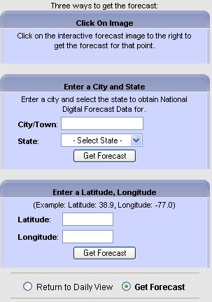
- The NDFD forecast image has two modes: Click on the image to either (1.) zoom in or (2.) get the text forecast for the exact point clicked on.
- Click on the radio button above the NDFD forecast image to change the page mode.
- For users who prefer to enter a specific latitude/longitude or city and state, the values can be filled in once the page mode is switched to "Get Text Forecast" mode.